The Great Flood of 1993—Recordbreaking Peaks
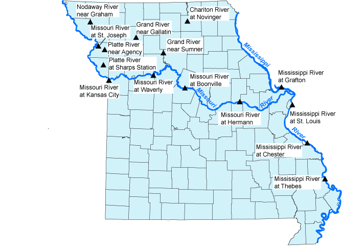
 

Map of USGS streamgaging stations affected on the Missouri and Mississippi Rivers during the 1993 Flood Chart depicting 1993 Flood Discharge, Mean Daily Discharge, and National Weather Service Flood Discharge for the Mississippi River at Thebes, Station 07022000. Chart depicting 1993 Flood Discharge, Mean Daily Discharge, and National Weather Service Flood Discharge for the Mississippi River at Chester, Station 07020500. Chart depicting 1993 Flood Discharge, Mean Daily Discharge, and National Weather Service Flood Discharge for the Mississippi River at St. Louis, Station 07010000. Chart depicting 1993 Flood Discharge, Mean Daily Discharge, and National Weather Service Flood Discharge for the Missouri River at Hermann, Station 06934500. Chart depicting 1993 Flood Discharge, Mean Daily Discharge, and National Weather Service Flood Discharge for the Mississippi River at Grafton, Station 05587450. Chart depicting 1993 Flood Discharge, Mean Daily Discharge, and National Weather Service Flood Discharge for the Missouri River at Boonville, Station 06909000. Chart depicting 1993 Flood Discharge, Mean Daily Discharge, and National Weather Service Flood Discharge for the Missouri River at Waverly, Station 06895500 Chart depicting 1993 Flood Discharge, Mean Daily Discharge, and National Weather Service Flood Discharge for the Missouri River at Kansas City, Station 06893000 Chart depicting 1993 Flood Discharge, Mean Daily Discharge, and National Weather Service Flood Discharge for the Platte River at Sharps Station, Station 06821190. Chart depicting 1993 Flood Discharge, Mean Daily Discharge, and National Weather Service Flood Discharge for the Grand River near Sumner, Station 06902000. Chart depicting 1993 Flood Discharge, Mean Daily Discharge, and National Weather Service Flood Discharge for the Platte River near Agency, Station 06820500. Chart depicting 1993 Flood Discharge, Mean Daily Discharge, and National Weather Service Flood Discharge for the Grand River near Gallatin, Station 06897500. Chart depicting 1993 Flood Discharge, Mean Daily Discharge, and National Weather Service Flood Discharge for the Missouri River at St, Joseph, Station 06818000 Chart depicting 1993 Flood Discharge and Mean Daily Discharge for the Nodaway River near Graham, Station 06817700 Chart depicting 1993 Flood Discharge and Mean Daily Discharge for the Chariton River at Novinger, Station 06904500  


The National Weather Service Flood Stage, 1993 Peak Gage Height, 1993 Rated Discharge and Date of Record Peaks of the 1993 Flood in Missouri.
Gage Location Station Number NWS Flood Stage (ft) 1993 Peak Gage Height (ft) 1993 Rated Discharge (cfs) Date
1993 Peak-Discharge Link Real-Time Link        
Mississippi River at Grafton 05587450 18 38.17 598,000 8/1/1993
Nodaway River near Graham 06817700 -- 26.16 78,300 7/23/1993
Missouri River at St. Joseph 06818000 17 32.07 335,000 7/26/1993
Platte River near Agency 06820500 20 36.07 60,800 7/25/1993
Platte River at Sharps Station 06821190 26 36.43 37,800 7/26/1993
Missouri River at Kansas City 06893000 32 48.87 541,000 7/27/1993
Missouri River at Waverly 06895500 20 31.15 633,000 7/27/1993
Grand River near Gallatin 06897500 26 41.50 89,800 7/7/1993
Grand River near Sumner 06902000 26 42.52 159,000 7/10/1993
Chariton River at Novinger 06904500 20 25.71 21,500 7/24/1993
Missouri River at Boonville 06909000 21 37.10 755,000 7/29/1993
Missouri River at Hermann 06934500 21 36.97 750,000 7/31/1993
Mississippi River at St. Louis 07010000 30 49.58 1,080,000 8/1/1993
Mississippi River at Chester 07020500 27 49.74 1,000,000 8/7/1993
Mississippi River at Thebes 07022000 33 45.51 996,000 8/7/1993